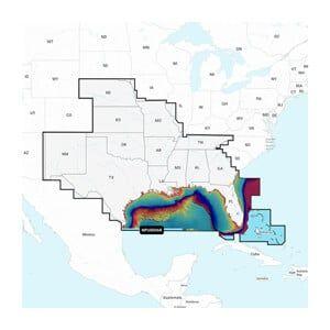


GARMIN Navionics+ U.S. North – Lakes, Rivers and Coastal Marine Charts
The GARMIN Navionics+ U.S. North is a comprehensive marine chart system designed for navigation across lakes, rivers, and coastal waters. This unit provides detailed mapping for safe and efficient boating, specifically covering the U.S. North region.
Compatibility & Applications
- Wires to GARMIN chartplotters for enhanced navigation.
- Pairs with GARMIN devices for integrated mapping solutions.
- Fits fishing boats, recreational crafts, and yachts.
- Updates can be accessed via the GARMIN ActiveCaptain app.
- Replaces older GARMIN chart models for updated navigation data.
- Mounts in standard SD card slots on compatible devices.
This unit enhances navigation accuracy with detailed charts, making it essential for freshwater and coastal environments. It is designed for use with GARMIN chartplotters, ensuring optimal functionality during marine excursions and providing up-to-date navigation data compared to older models.