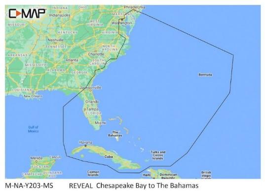

C-MAP Reveal – Chesapeake Bay To The Bahamas

Part Number: M-NA-Y203-MS · Category: Marine Charts & Maps

C-MAP

$260.00

In stock · ships from Pompano Beach, FL

13 in stock

Request a QuoteSeveral units or a fleet job? Ask for volume pricing.
Item
Shipping
Total
Oversize item: call (786) 277-2596 for a freight quote.
Ships from Pompano Beach, FL. Rate shown is for Florida (1-2 business days); other states 1 to 7 business days, exact rate by ZIP at checkout.
★★★★★ 5.0 rated on Google (21 reviews) · ✓ 30-day returns · ✓ Secure payment by Stripe

We sell it. We install it.

Professional marine electronics installation available in South Florida. Free quotes, and boat pickup and transport for qualifying boats and projects.

Get an Installation Quote Call +1 (786) 277-2596

Shipping & sourcing
  • Ships from Pompano Beach, FL, United States.
  • Handling: 1 business day. Delivery: 1 to 7 business days within the United States.
  • Shipping is calculated at checkout by the carrier. Orders of $199 or more ship free.
  • Product images and specifications are supplied by the manufacturer.
Shipping & returns policy
0 People watching this product now!

Payment Methods:

Product details

BrandC-MAP
Part NumberM-NA-Y203-MS
CategoryMarine Charts & Maps
AvailabilityIn stock
Ships fromPompano Beach, FL · 1 business day handling
InstallationAvailable in Pompano Beach and Broward County
Weight0.5 lbs

C-MAP Reveal – Chesapeake Bay To The Bahamas Mapping Solution

The C-MAP Reveal – Chesapeake Bay To The Bahamas is a premium mapping solution compatible with Lowrance, Simrad, and B&G chartplotters. This unit features shaded relief for enhanced visualization of underwater and coastal topography, providing critical navigation data for mariners.

Compatibility & Applications

  • Fits Lowrance, Simrad, and B&G chartplotters for easy installation.
  • Integrates with existing marine navigation systems for seamless functionality.
  • Provides enhanced visualization for cruisers, anglers, and sailors navigating coastal waters.
  • Replaces older C-MAP chart products for updated mapping accuracy.
  • Mounts easily in both coastal and offshore navigation settings.

The unit delivers advanced mapping capabilities for navigating from the Chesapeake Bay to the Bahamas, offering detailed geographic information. It serves as a drop-in replacement for older C-MAP charts, ensuring mariners have the latest data for safe navigation.

Technical Specifications

Weight 0.07 lbs
Dimensions (L × W × H) 4.00 × 6.00 × 1.00 in
Weight0.5 lbs
Dimensions4 × 6 × 1 in
Weight0.07 lbs (0.03 kg)
Dimensions4 x 6 x 0 in (102 x 152 x 0 mm)
CompatibilityLowrance, Simrad, B&G Chartplotters
Features3D rendered land and underwater shaded relief
Data TypeMarine navigation charts
Country of OriginUSA
Warranty1 year
IP RatingIPX7
MFG#M-NA-Y203-MS
UPC9420064118922
0 reviews
0
0
0
0
0

There are no reviews yet.

Be the first to review “C-MAP Reveal – Chesapeake Bay To The Bahamas”

Your email address will not be published. Required fields are marked *

1 2 3 4 5
1 2 3 4 5
1 2 3 4 5

Description

C-MAP Reveal – Chesapeake Bay To The Bahamas Mapping Solution

The C-MAP Reveal – Chesapeake Bay To The Bahamas is a premium mapping solution compatible with Lowrance, Simrad, and B&G chartplotters. This unit features shaded relief for enhanced visualization of underwater and coastal topography, providing critical navigation data for mariners.

Compatibility & Applications

  • Fits Lowrance, Simrad, and B&G chartplotters for easy installation.
  • Integrates with existing marine navigation systems for seamless functionality.
  • Provides enhanced visualization for cruisers, anglers, and sailors navigating coastal waters.
  • Replaces older C-MAP chart products for updated mapping accuracy.
  • Mounts easily in both coastal and offshore navigation settings.

The unit delivers advanced mapping capabilities for navigating from the Chesapeake Bay to the Bahamas, offering detailed geographic information. It serves as a drop-in replacement for older C-MAP charts, ensuring mariners have the latest data for safe navigation.

Technical Specifications

Weight 0.07 lbs
Dimensions (L × W × H) 4.00 × 6.00 × 1.00 in

Specification

Overview

Weight0.5 lbs
Dimensions4 × 6 × 1 in
Weight0.07 lbs (0.03 kg)
Dimensions4 x 6 x 0 in (102 x 152 x 0 mm)
CompatibilityLowrance, Simrad, B&G Chartplotters
Features3D rendered land and underwater shaded relief
Data TypeMarine navigation charts
Country of OriginUSA
Warranty1 year
IP RatingIPX7
MFG#M-NA-Y203-MS
UPC9420064118922

Customer Reviews

0 reviews
0
0
0
0
0

There are no reviews yet.

Be the first to review “C-MAP Reveal – Chesapeake Bay To The Bahamas”

Your email address will not be published. Required fields are marked *

1 2 3 4 5
1 2 3 4 5
1 2 3 4 5