
Performance Metals Yamaha Trim Tab Anode 150-200hp Counter Rotating
Performance Metals Yamaha Trim Tab Anode 150-200hp Counter Rotating Original price was: $28.51.Current price is: $18.43.
Back to products
Veratron Deep-Pipe Level Sender - 320mm - 90 to 4 OHM
Veratron Deep-Pipe Level Sender - 320mm - 90 to 4 OHM Original price was: $83.60.Current price is: $75.24.

Garmin VEU722L Europe Atlantic Coast BlueChart® g3 Vision®

Garmin marine products include transducers, navigation parts and accessories, chartplotters, marine charts and maps, trolling motors, and communication/network equipment. Garmin product lines include GPSMAP, GMR Fantom, GMR xHD3, and Navionics+.

Part Number: 010-C1156-00 · Category: Marine Charts & Maps

Garmin

$349.99

Out of stock

★★★★★ 5.0 rated on Google (21 reviews) · ✓ 30-day returns · ✓ Secure payment by Stripe

We also install it: professional marine electronics installation in South Florida.

Shipping & sourcing
  • Ships from Pompano Beach, FL, United States.
  • Handling: 1 business day. Delivery: 1 to 7 business days within the United States.
  • Shipping is calculated at checkout by the carrier. Orders of $199 or more ship free.
  • Product images and specifications are supplied by the manufacturer.
Shipping & returns policy
0 People watching this product now!

Payment Methods:

Product details

BrandGarmin
Part Number010-C1156-00
CategoryMarine Charts & Maps
AvailabilitySpecial order
Ships fromPompano Beach, FL · lead time confirmed when you order
InstallationAvailable in Pompano Beach and Broward County

VEU722L Europe Atlantic Coast BlueChart® g3 Vision®

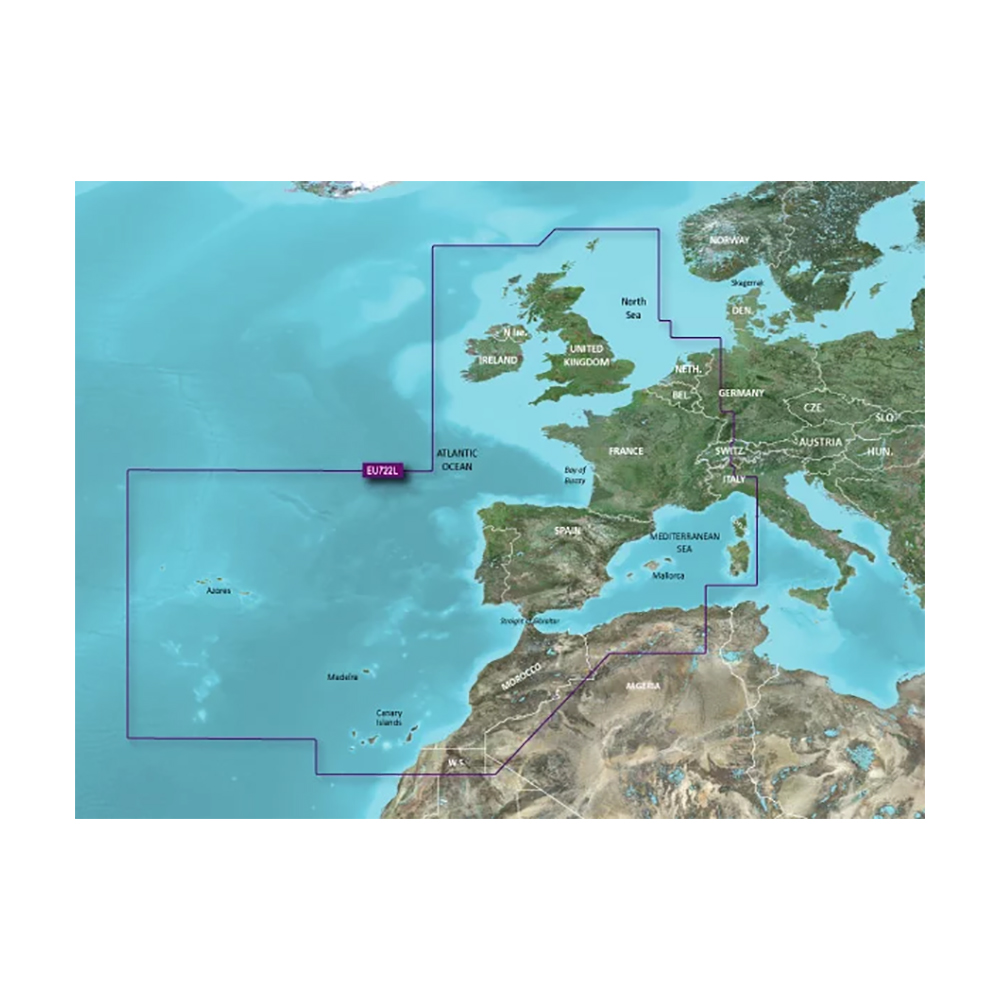
Detailed coverage of the Atlantic and Mediterranean coast of Western Europe, the British Isles and northwestern Africa. Coverage includes the Azores, Canary, Balearic, Channel, and Shetland Islands; Sardinia, Corsica and Madeira, the western Mediterranean Sea from La Spezia, IT to the Strait of Gibraltar, Bay of Biscay, English Channel, Irish Sea, Waddenzee, IJsselmeer, the inland canals and waterways of France and Benelux; the Garonne, Loire, Seine and Rhone River systems; the Rhine River to Neuwied, DE; Lake Leman (Geneva), the entire British Isles including Lough Neagh, the Caledonian Canal, the Isles of Wight and Man and the Thames River and Estuary; the coast of Africa from Cape Bojador, EH to Cape Bougaroun, DZ.

Premier Coastal Charts:

  • Industry-leading coverage, clarity and detail with updated coastal charts that feature integrated Garmin and Navionics® content
  • Auto Guidance¹ technology quickly calculates a suggested route by using your desired depth and overhead clearance
  • Includes Depth Range Shading for up to 10 depth ranges, enabling you to view your target depth at a glance
  • Up to 1’ contours provide a more accurate depiction of the bottom structure for improved fishing charts
  • To give a clear picture of shallow waters to avoid, the Shallow Water Shading allows for shading at a user-defined depth

Experience unparalleled coverage and brilliant detail when you’re on the water. BlueChart g3 Vision coastal charts provide industry-leading coverage, clarity and detail with integrated Garmin and Navionics content.

WarningWARNING: This product can expose you to chemicals which are known to the State of California to cause cancer, birth defects or other reproductive harm. For more information go to P65Warnings.ca.gov.

MFG#010-C1156-00
UPC753759205324
0 reviews
0
0
0
0
0

There are no reviews yet.

Be the first to review “Garmin VEU722L Europe Atlantic Coast BlueChart® g3 Vision®”

Your email address will not be published. Required fields are marked *

1 2 3 4 5
1 2 3 4 5
1 2 3 4 5

Garmin marine products include transducers, navigation parts and accessories, chartplotters, marine charts and maps, trolling motors, and communication/network equipment. Garmin product lines include GPSMAP, GMR Fantom, GMR xHD3, and Navionics+.

Description

VEU722L Europe Atlantic Coast BlueChart® g3 Vision®

Detailed coverage of the Atlantic and Mediterranean coast of Western Europe, the British Isles and northwestern Africa. Coverage includes the Azores, Canary, Balearic, Channel, and Shetland Islands; Sardinia, Corsica and Madeira, the western Mediterranean Sea from La Spezia, IT to the Strait of Gibraltar, Bay of Biscay, English Channel, Irish Sea, Waddenzee, IJsselmeer, the inland canals and waterways of France and Benelux; the Garonne, Loire, Seine and Rhone River systems; the Rhine River to Neuwied, DE; Lake Leman (Geneva), the entire British Isles including Lough Neagh, the Caledonian Canal, the Isles of Wight and Man and the Thames River and Estuary; the coast of Africa from Cape Bojador, EH to Cape Bougaroun, DZ.

Premier Coastal Charts:

  • Industry-leading coverage, clarity and detail with updated coastal charts that feature integrated Garmin and Navionics® content
  • Auto Guidance¹ technology quickly calculates a suggested route by using your desired depth and overhead clearance
  • Includes Depth Range Shading for up to 10 depth ranges, enabling you to view your target depth at a glance
  • Up to 1’ contours provide a more accurate depiction of the bottom structure for improved fishing charts
  • To give a clear picture of shallow waters to avoid, the Shallow Water Shading allows for shading at a user-defined depth

Experience unparalleled coverage and brilliant detail when you’re on the water. BlueChart g3 Vision coastal charts provide industry-leading coverage, clarity and detail with integrated Garmin and Navionics content.

WarningWARNING: This product can expose you to chemicals which are known to the State of California to cause cancer, birth defects or other reproductive harm. For more information go to P65Warnings.ca.gov.
Specification

Overview

MFG#010-C1156-00
UPC753759205324

Customer Reviews

0 reviews
0
0
0
0
0

There are no reviews yet.

Be the first to review “Garmin VEU722L Europe Atlantic Coast BlueChart® g3 Vision®”

Your email address will not be published. Required fields are marked *

1 2 3 4 5
1 2 3 4 5
1 2 3 4 5