
Garmin HP024R Bluechart G3 Australia And New Zealand

Garmin marine products include transducers, navigation parts and accessories, chartplotters, marine charts and maps, trolling motors, and communication/network equipment. Garmin product lines include GPSMAP, GMR Fantom, GMR xHD3, and Navionics+.

Part Number: 010-C1020-20 · Category: Marine Charts & Maps

Garmin

$289.99

In stock · ships from Pompano Beach, FL

3 in stock

Request a QuoteSeveral units or a fleet job? Ask for volume pricing.
Item
Shipping
Total
Oversize item: call (786) 277-2596 for a freight quote.
Ships from Pompano Beach, FL. Rate shown is for Florida (1-2 business days); other states 1 to 7 business days, exact rate by ZIP at checkout.
★★★★★ 5.0 rated on Google (21 reviews) · ✓ 30-day returns · ✓ Secure payment by Stripe

We sell it. We install it.

Professional marine electronics installation available in South Florida. Free quotes, and boat pickup and transport for qualifying boats and projects.

Get an Installation Quote Call +1 (786) 277-2596

Shipping & sourcing
  • Ships from Pompano Beach, FL, United States.
  • Handling: 1 business day. Delivery: 1 to 7 business days within the United States.
  • Shipping is calculated at checkout by the carrier. Orders of $199 or more ship free.
  • Product images and specifications are supplied by the manufacturer.
Shipping & returns policy
0 People watching this product now!

Payment Methods:

Product details

BrandGarmin
Part Number010-C1020-20
CategoryMarine Charts & Maps
AvailabilityIn stock
Ships fromPompano Beach, FL · 1 business day handling
InstallationAvailable in Pompano Beach and Broward County
Weight0.20 lbs

Garmin HXPC024R Vision G3 Australia & New Zealand
HXUS604X – microSDTM/SDTM card

Model: 010-C1020-20

  • Derived from official charts and private sources to provide navigational aids, spot soundings, depth contours, tides and currents, and detailed harbors and marinas
  • Depth Range Shading for up to 10 depth ranges enables you to view your target depth at a glance
  • Up to 1-foot contours provide a more accurate depiction of the bottom structure for improved fishing charts and navigation in swamps, canals and marinas
  • Shallow Water Shading feature allows for depth shading at a user-defined level to aid in navigation
  • Worldwide coverage available
  • Keep your charts up to date with our industry-leading New Chart Guarantee and discount card update program

Detailed charts help the mariner guide their boat in and out of port with confidence.

Displays high-resolution Depth Range Shading for up to 10 depth ranges so you can view your designated target depth.

BlueChart g2 HD features 1-foot contours that provide a more accurate depiction of bottom structure for improved fishing charts and enhanced detail in swamps, canals and port plans.

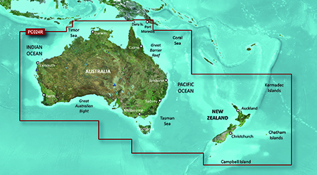
Detailed coverage of Australia, New Zealand and many associated islands. Coverage includes the Great Barrier Reef, Tasmania, Norfolk Island, Campbell Island, the Auckland Islands, the Antipode Islands, the Bounty Islands, the Chatham Islands and the Kermadec Islands. Ports include Sydney, Melbourne, Perth, Darwin and Cairns in Australia; Wellington, Auckland, Nelson and Dunedin in New Zealand and Port Moresby, Papua-New Guinea.

Specifications

g2 HD
1 feet HD Contours Yes
Depth Range Shading Yes
Shallow Water Shading Yes
Navigational aids, spot soundings, depth contours, tides and currents and detailed harbors and marinas Yes
g2 Vision HD
1 feet HD Contours Yes
Depth Range Shading Yes
Shallow Water Shading Yes
Navigational aids, spot soundings, depth contours, tides and currents and detailed harbors and marinas Yes
Auto Guidance Yes
3-D Views (MarinerEye & FishEye) Yes
High Resolution Satellite Imagery Yes
Aerial Photography Yes
Detailed coastal roads up to 5 miles inland Yes
Weight0.20 lbs
MFG#010-C1020-20
UPC753759095499
0 reviews
0
0
0
0
0

There are no reviews yet.

Be the first to review “Garmin HP024R Bluechart G3 Australia And New Zealand”

Your email address will not be published. Required fields are marked *

1 2 3 4 5
1 2 3 4 5
1 2 3 4 5

Garmin marine products include transducers, navigation parts and accessories, chartplotters, marine charts and maps, trolling motors, and communication/network equipment. Garmin product lines include GPSMAP, GMR Fantom, GMR xHD3, and Navionics+.

Description

Garmin HXPC024R Vision G3 Australia & New Zealand
HXUS604X – microSDTM/SDTM card

Model: 010-C1020-20

  • Derived from official charts and private sources to provide navigational aids, spot soundings, depth contours, tides and currents, and detailed harbors and marinas
  • Depth Range Shading for up to 10 depth ranges enables you to view your target depth at a glance
  • Up to 1-foot contours provide a more accurate depiction of the bottom structure for improved fishing charts and navigation in swamps, canals and marinas
  • Shallow Water Shading feature allows for depth shading at a user-defined level to aid in navigation
  • Worldwide coverage available
  • Keep your charts up to date with our industry-leading New Chart Guarantee and discount card update program

Detailed charts help the mariner guide their boat in and out of port with confidence.

Displays high-resolution Depth Range Shading for up to 10 depth ranges so you can view your designated target depth.

BlueChart g2 HD features 1-foot contours that provide a more accurate depiction of bottom structure for improved fishing charts and enhanced detail in swamps, canals and port plans.

Detailed coverage of Australia, New Zealand and many associated islands. Coverage includes the Great Barrier Reef, Tasmania, Norfolk Island, Campbell Island, the Auckland Islands, the Antipode Islands, the Bounty Islands, the Chatham Islands and the Kermadec Islands. Ports include Sydney, Melbourne, Perth, Darwin and Cairns in Australia; Wellington, Auckland, Nelson and Dunedin in New Zealand and Port Moresby, Papua-New Guinea.

Specifications

g2 HD
1 feet HD Contours Yes
Depth Range Shading Yes
Shallow Water Shading Yes
Navigational aids, spot soundings, depth contours, tides and currents and detailed harbors and marinas Yes
g2 Vision HD
1 feet HD Contours Yes
Depth Range Shading Yes
Shallow Water Shading Yes
Navigational aids, spot soundings, depth contours, tides and currents and detailed harbors and marinas Yes
Auto Guidance Yes
3-D Views (MarinerEye & FishEye) Yes
High Resolution Satellite Imagery Yes
Aerial Photography Yes
Detailed coastal roads up to 5 miles inland Yes

Specification

Overview

Weight0.20 lbs
MFG#010-C1020-20
UPC753759095499

Customer Reviews

0 reviews
0
0
0
0
0

There are no reviews yet.

Be the first to review “Garmin HP024R Bluechart G3 Australia And New Zealand”

Your email address will not be published. Required fields are marked *

1 2 3 4 5
1 2 3 4 5
1 2 3 4 5