
Panther 12' King Pin Anchor Pole - 2-Piece - Black
Panther 12' King Pin Anchor Pole - 2-Piece - Black Original price was: $134.24.Current price is: $115.17.
Back to products
Attwood Fuel Tank Strap Set - 72" Long f/12 Gallon Tanks
Attwood Fuel Tank Strap Set - 72" Long f/12 Gallon Tanks Original price was: $14.99.Current price is: $11.64.

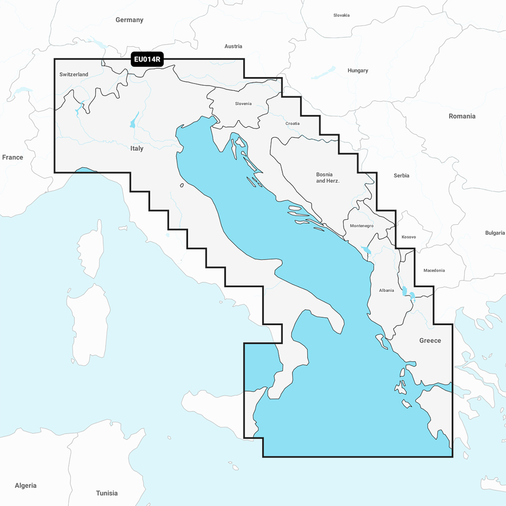
Garmin Navionics+ NSEU014R – Italy, Adriatic Sea – Marine Chart

Garmin marine products include transducers, navigation parts and accessories, chartplotters, marine charts and maps, trolling motors, and communication/network equipment. Garmin product lines include GPSMAP, GMR Fantom, GMR xHD3, and Navionics+.

Part Number: 010-C1239-20 · Category: Marine Charts & Maps

Garmin

$159.99

Out of stock

★★★★★ 5.0 rated on Google (21 reviews) · ✓ 30-day returns · ✓ Secure payment by Stripe

We also install it: professional marine electronics installation in South Florida.

Shipping & sourcing
  • Ships from Pompano Beach, FL, United States.
  • Handling: 1 business day. Delivery: 1 to 7 business days within the United States.
  • Shipping is calculated at checkout by the carrier. Orders of $199 or more ship free.
  • Product images and specifications are supplied by the manufacturer.
Shipping & returns policy
0 People watching this product now!

Payment Methods:

Product details

BrandGarmin
Part Number010-C1239-20
CategoryMarine Charts & Maps
AvailabilitySpecial order
Ships fromPompano Beach, FL · lead time confirmed when you order
InstallationAvailable in Pompano Beach and Broward County

Navionics+ NSEU014R – Italy, Adriatic Sea – Marine Chart

Get the world’s No. 1 choice in the marine mapping with the best, most up-to-date Navionics®+ cartography on your compatible chartplotter. 

Featuring vibrant colors, a streamlined interface and combined coastal/inland content with a popular Navionics® style color palette, Garmin Navionics+ cartography makes it easy to plot your course.  Multiple shading options aid in shallow water navigation and make it easy to highlight a target depth range for the best fishing spots.   Fully customizable with various chart layers, overlay combinations and up to 10 color-shaded target depth ranges to scope out the best fishing spots.

When you purchase a new Garmin Navionics+ or Garmin Navionics Vision+ cartography product, a one-year subscription is included.  

Chart Code – NSEU014R

Coverage Area:

Coastal coverage of the Po River and the Adriatic coast of Italy, Slovenia, Croatia, Albania, the western coast of Greece and southern Italy. Coverage includes eastern Sicily, the Straits of Messina, the Dalmatian Coast, the Gulf of Taranto, Lago Maggiore, Lago d’Iseo, Lago di Como and Lago di Garda.

Features:

  • All-in-one Map Solution – Access detail-rich mapping of coastal features, lakes, rivers and more.  Integrated Garmin and Navionics® content offers coverage for boaters worldwide. 
  • Daily Chart Updates – Charts are constantly being enhanced with new and amended content — as many as 5,000 updates are made every day.  The one-year included subscription gives you access to daily chart updates via the ActiveCaptain app. 
  • Auto Guidance+ Technology – Combining the best of Garmin and Navionics automatic routing features, built-in Auto Guidance+ technology1 gives you a suggested dock-to-dock path to follow through channels, inlets, marina entrances and more. 
  • Depth Range Shading – High-resolution depth range shading lets you select up to 10 color-shaded options and view your designated target depths at a glance. 
  • Up to 1′ Contours – For improved fishing and navigation, up to 1′ contours provide a clear depiction of bottom structure for improved fishing charts and enhanced detail in swamps, canals, harbors, marinas and more. 
  • Shallow Water Shading – To give a clear picture of shallow waters to avoid, this feature allows for shading at a user-defined depth. 
  • ActiveCaptain Community – Community-sourced content provides useful POIs, such as marinas, anchorages, hazards, businesses and more. Get recommendations from boaters with firsthand experience of the local environment. 

Compatibility:

  • Check the compatibility of Garmin Navionics+ content and features with your GPS chartplotter.

Technical Specifications:

  • Format – MicroSD/SD Card

In the Box:

  • SD/MSD Card

1Auto Guidance+ is for planning purposes only and does not replace safe navigation operations 

*Sold as an Individual


MFG#010-C1239-20
0 reviews
0
0
0
0
0

There are no reviews yet.

Be the first to review “Garmin Navionics+ NSEU014R – Italy, Adriatic Sea – Marine Chart”

Your email address will not be published. Required fields are marked *

1 2 3 4 5
1 2 3 4 5
1 2 3 4 5

Garmin marine products include transducers, navigation parts and accessories, chartplotters, marine charts and maps, trolling motors, and communication/network equipment. Garmin product lines include GPSMAP, GMR Fantom, GMR xHD3, and Navionics+.

Description

Navionics+ NSEU014R – Italy, Adriatic Sea – Marine Chart

Get the world’s No. 1 choice in the marine mapping with the best, most up-to-date Navionics®+ cartography on your compatible chartplotter. 

Featuring vibrant colors, a streamlined interface and combined coastal/inland content with a popular Navionics® style color palette, Garmin Navionics+ cartography makes it easy to plot your course.  Multiple shading options aid in shallow water navigation and make it easy to highlight a target depth range for the best fishing spots.   Fully customizable with various chart layers, overlay combinations and up to 10 color-shaded target depth ranges to scope out the best fishing spots.

When you purchase a new Garmin Navionics+ or Garmin Navionics Vision+ cartography product, a one-year subscription is included.  

Chart Code – NSEU014R

Coverage Area:

Coastal coverage of the Po River and the Adriatic coast of Italy, Slovenia, Croatia, Albania, the western coast of Greece and southern Italy. Coverage includes eastern Sicily, the Straits of Messina, the Dalmatian Coast, the Gulf of Taranto, Lago Maggiore, Lago d’Iseo, Lago di Como and Lago di Garda.

Features:

  • All-in-one Map Solution – Access detail-rich mapping of coastal features, lakes, rivers and more.  Integrated Garmin and Navionics® content offers coverage for boaters worldwide. 
  • Daily Chart Updates – Charts are constantly being enhanced with new and amended content — as many as 5,000 updates are made every day.  The one-year included subscription gives you access to daily chart updates via the ActiveCaptain app. 
  • Auto Guidance+ Technology – Combining the best of Garmin and Navionics automatic routing features, built-in Auto Guidance+ technology1 gives you a suggested dock-to-dock path to follow through channels, inlets, marina entrances and more. 
  • Depth Range Shading – High-resolution depth range shading lets you select up to 10 color-shaded options and view your designated target depths at a glance. 
  • Up to 1′ Contours – For improved fishing and navigation, up to 1′ contours provide a clear depiction of bottom structure for improved fishing charts and enhanced detail in swamps, canals, harbors, marinas and more. 
  • Shallow Water Shading – To give a clear picture of shallow waters to avoid, this feature allows for shading at a user-defined depth. 
  • ActiveCaptain Community – Community-sourced content provides useful POIs, such as marinas, anchorages, hazards, businesses and more. Get recommendations from boaters with firsthand experience of the local environment. 

Compatibility:

  • Check the compatibility of Garmin Navionics+ content and features with your GPS chartplotter.

Technical Specifications:

  • Format – MicroSD/SD Card

In the Box:

  • SD/MSD Card

1Auto Guidance+ is for planning purposes only and does not replace safe navigation operations 

*Sold as an Individual
 

Specification

Overview

MFG#010-C1239-20

Customer Reviews

0 reviews
0
0
0
0
0

There are no reviews yet.

Be the first to review “Garmin Navionics+ NSEU014R – Italy, Adriatic Sea – Marine Chart”

Your email address will not be published. Required fields are marked *

1 2 3 4 5
1 2 3 4 5
1 2 3 4 5