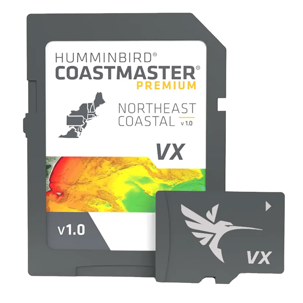

Humminbird CoastMaster® Premium Northeast Coastal V1

Humminbird marine products include transducers, navigation parts and accessories, marine charts and maps, chartplotters, fishing and sonar equipment, and communication/network products. Product lines include APEX, XPLORE, HELIX, MEGA Live, and MEGA 360 Imaging.

Part Number: 602024-1 · Category: Marine Charts & Maps

Humminbird

$329.99

In stock · ships from Pompano Beach, FL

5 in stock

Request a QuoteSeveral units or a fleet job? Ask for volume pricing.
Item
Shipping
Total
Oversize item: call (786) 277-2596 for a freight quote.
Ships from Pompano Beach, FL. Rate shown is for Florida (1-2 business days); other states 1 to 7 business days, exact rate by ZIP at checkout.
★★★★★ 5.0 rated on Google (21 reviews) · ✓ 30-day returns · ✓ Secure payment by Stripe

We sell it. We install it.

Professional marine electronics installation available in South Florida. Free quotes, and boat pickup and transport for qualifying boats and projects.

Get an Installation Quote Call +1 (786) 277-2596

Shipping & sourcing
  • Ships from Pompano Beach, FL, United States.
  • Handling: 1 business day. Delivery: 1 to 7 business days within the United States.
  • Shipping is calculated at checkout by the carrier. Orders of $199 or more ship free.
  • Product images and specifications are supplied by the manufacturer.
Shipping & returns policy
0 People watching this product now!

Payment Methods:

Product details

BrandHumminbird
Part Number602024-1
CategoryMarine Charts & Maps
AvailabilityIn stock
Ships fromPompano Beach, FL · 1 business day handling
InstallationAvailable in Pompano Beach and Broward County
Weight0.15 lbs

Humminbird CoastMaster Premium Northeast Coastal V1 Marine Chart

The Humminbird CoastMaster Premium Northeast Coastal V1 is a marine chart for Northeast coastal coverage, delivered on an SD card. The chart provides shaded relief, aerial imagery, depth highlights, and chart presets for Humminbird chartplotter users installing coverage from New York to Maine.

Technical Specifications

Coverage Area U.S. Northeast Coastal, New York to Maine
Delivery SD Card
Product Type CoastMaster marine chart
Region Northeast
Shallow Water Highlight Adjustable range from 0 to 60 feet
Warranty One-year cartography warranty

Compatibility & Applications

  • Fits Humminbird HELIX G3/G3N, SOLIX, APEX, and XPLORE units.
  • Pairs with Minn Kota trolling motors through the One-Boat Network.
  • Highlights selected depth ranges for chart-based fishing location identification.
  • Displays 2D shaded relief for bottom detail and depth changes.
  • Uses aerial imagery to identify charted coastal locations and fishing spots.

Installed in a supported Humminbird SOLIX, APEX, or XPLORE unit, the SD card supplies Northeast coastal chart coverage from New York to Maine. Its differentiators include VX Technology, SmartStrike, 2D shaded relief, aerial imagery, and a selectable 0 to 60 foot shallow-water highlight.

FAQ

What is the Humminbird CoastMaster Premium Northeast Coastal V1?

It is a Northeast coastal marine chart delivered on an SD card, covering New York to Maine.

What equipment does the chart connect to?

It connects with supported Humminbird chartplotters and Minn Kota trolling motors through the One-Boat Network.

Weight0.15 lbs
Dimensions7.30 × 5.10 × 0.50 in
MFG#602024-1
UPC082324057977
0 reviews
0
0
0
0
0

There are no reviews yet.

Be the first to review “Humminbird CoastMaster® Premium Northeast Coastal V1”

Your email address will not be published. Required fields are marked *

1 2 3 4 5
1 2 3 4 5
1 2 3 4 5

Humminbird marine products include transducers, navigation parts and accessories, marine charts and maps, chartplotters, fishing and sonar equipment, and communication/network products. Product lines include APEX, XPLORE, HELIX, MEGA Live, and MEGA 360 Imaging.

Description

Humminbird CoastMaster Premium Northeast Coastal V1 Marine Chart

The Humminbird CoastMaster Premium Northeast Coastal V1 is a marine chart for Northeast coastal coverage, delivered on an SD card. The chart provides shaded relief, aerial imagery, depth highlights, and chart presets for Humminbird chartplotter users installing coverage from New York to Maine.

Technical Specifications

Coverage Area U.S. Northeast Coastal, New York to Maine
Delivery SD Card
Product Type CoastMaster marine chart
Region Northeast
Shallow Water Highlight Adjustable range from 0 to 60 feet
Warranty One-year cartography warranty

Compatibility & Applications

  • Fits Humminbird HELIX G3/G3N, SOLIX, APEX, and XPLORE units.
  • Pairs with Minn Kota trolling motors through the One-Boat Network.
  • Highlights selected depth ranges for chart-based fishing location identification.
  • Displays 2D shaded relief for bottom detail and depth changes.
  • Uses aerial imagery to identify charted coastal locations and fishing spots.

Installed in a supported Humminbird SOLIX, APEX, or XPLORE unit, the SD card supplies Northeast coastal chart coverage from New York to Maine. Its differentiators include VX Technology, SmartStrike, 2D shaded relief, aerial imagery, and a selectable 0 to 60 foot shallow-water highlight.

FAQ

What is the Humminbird CoastMaster Premium Northeast Coastal V1?

It is a Northeast coastal marine chart delivered on an SD card, covering New York to Maine.

What equipment does the chart connect to?

It connects with supported Humminbird chartplotters and Minn Kota trolling motors through the One-Boat Network.
Specification

Overview

Weight0.15 lbs
Dimensions7.30 × 5.10 × 0.50 in
MFG#602024-1
UPC082324057977

Customer Reviews

0 reviews
0
0
0
0
0

There are no reviews yet.

Be the first to review “Humminbird CoastMaster® Premium Northeast Coastal V1”

Your email address will not be published. Required fields are marked *

1 2 3 4 5
1 2 3 4 5
1 2 3 4 5