
Garmin BlueChart® g3 Vision® VEI510S – Dnieper River & Azov Sea – microSD™/SD™

Garmin marine products include transducers, navigation parts and accessories, chartplotters, marine charts and maps, trolling motors, and communication/network equipment. Garmin product lines include GPSMAP, GMR Fantom, GMR xHD3, and Navionics+.

Part Number: 010-C1128-00 · Category: Marine Charts & Maps

Garmin

$174.99

Out of stock

★★★★★ 5.0 rated on Google (21 reviews) · ✓ 30-day returns · ✓ Secure payment by Stripe

We also install it: professional marine electronics installation in South Florida.

Shipping & sourcing
  • Ships from Pompano Beach, FL, United States.
  • Handling: 1 business day. Delivery: 1 to 7 business days within the United States.
  • Shipping is calculated at checkout by the carrier. Orders of $199 or more ship free.
  • Product images and specifications are supplied by the manufacturer.
Shipping & returns policy
0 People watching this product now!

Payment Methods:

Product details

BrandGarmin
Part Number010-C1128-00
CategoryMarine Charts & Maps
AvailabilitySpecial order
Ships fromPompano Beach, FL · lead time confirmed when you order
InstallationAvailable in Pompano Beach and Broward County

BlueChart® g3 Vision® VEI510S – Dnieper River & Azov Sea 

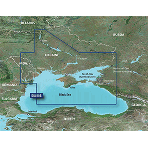
Coverage: Detailed coverage of the Dnieper River from the Belarus-Ukrainian border to the Black Sea, the Sea of Azov and the Black Sea coast from the Danube Delta to Sochi, Russia, including the entire Crimean coast. Coverage includes the Kuban River to Krasnodar, the Kerch Strait, the Don River to Bagayevskiy and the Danube River to Braila, Romania.

See your vessel’s precise, on-chart position in relation to navaids, coastal features and restricted areas with premium features found in this detailed marine mapping data. Includes all of the features of our BlueChart® g2 HD product, plus 3-D perspective above and below the waterline, Auto Guidance, high-resolution imagery, and aerial photos of ports, harbors, marinas and landmarks.

Features:

  • Shaded depth contours, coastlines, spot soundings, navaids, port plans, wrecks, obstructions, intertidal zones, restricted areas and IALA symbols
  • Features up to 1-foot HD fishing contours which reveal detailed seafloor terrain
  • Seamless transitions between zoom levels and more continuity across chart boundaries
  • High resolution satellite imagery for a realistic view of the land and wate
  • Aerial photos of ports, harbors, marinas, waterways, navigational landmarks and other POIs
  • Garmin Auto Guidance technology is now capable of providing routing guidance¹ to virtually any accessible destination on the water
  • Mariner’s Eye view 3-D perspective for a quick, easy position fix
  • Fish Eye view 3-D perspective for an underwater view of the sea floor
  • Safety Shading* enables contour shading for all depth contours shallower than your defined safe depths
  • Fishing Charts* to scope out bottom contours and depth soundings with less visual clutter on the display
  • Plan and organize routes from your computer with HomePort™

WarningWARNING: This product can expose you to chemicals which are known to the State of California to cause cancer, birth defects or other reproductive harm. For more information go to P65Warnings.ca.gov.

MFG#010-C1128-00
UPC753759145651
0 reviews
0
0
0
0
0

There are no reviews yet.

Be the first to review “Garmin BlueChart® g3 Vision® VEI510S – Dnieper River & Azov Sea – microSD™/SD™”

Your email address will not be published. Required fields are marked *

1 2 3 4 5
1 2 3 4 5
1 2 3 4 5

Garmin marine products include transducers, navigation parts and accessories, chartplotters, marine charts and maps, trolling motors, and communication/network equipment. Garmin product lines include GPSMAP, GMR Fantom, GMR xHD3, and Navionics+.

Description

BlueChart® g3 Vision® VEI510S – Dnieper River & Azov Sea 

Coverage: Detailed coverage of the Dnieper River from the Belarus-Ukrainian border to the Black Sea, the Sea of Azov and the Black Sea coast from the Danube Delta to Sochi, Russia, including the entire Crimean coast. Coverage includes the Kuban River to Krasnodar, the Kerch Strait, the Don River to Bagayevskiy and the Danube River to Braila, Romania.

See your vessel’s precise, on-chart position in relation to navaids, coastal features and restricted areas with premium features found in this detailed marine mapping data. Includes all of the features of our BlueChart® g2 HD product, plus 3-D perspective above and below the waterline, Auto Guidance, high-resolution imagery, and aerial photos of ports, harbors, marinas and landmarks.

Features:

  • Shaded depth contours, coastlines, spot soundings, navaids, port plans, wrecks, obstructions, intertidal zones, restricted areas and IALA symbols
  • Features up to 1-foot HD fishing contours which reveal detailed seafloor terrain
  • Seamless transitions between zoom levels and more continuity across chart boundaries
  • High resolution satellite imagery for a realistic view of the land and wate
  • Aerial photos of ports, harbors, marinas, waterways, navigational landmarks and other POIs
  • Garmin Auto Guidance technology is now capable of providing routing guidance¹ to virtually any accessible destination on the water
  • Mariner’s Eye view 3-D perspective for a quick, easy position fix
  • Fish Eye view 3-D perspective for an underwater view of the sea floor
  • Safety Shading* enables contour shading for all depth contours shallower than your defined safe depths
  • Fishing Charts* to scope out bottom contours and depth soundings with less visual clutter on the display
  • Plan and organize routes from your computer with HomePort™

WarningWARNING: This product can expose you to chemicals which are known to the State of California to cause cancer, birth defects or other reproductive harm. For more information go to P65Warnings.ca.gov.
Specification

Overview

MFG#010-C1128-00
UPC753759145651

Customer Reviews

0 reviews
0
0
0
0
0

There are no reviews yet.

Be the first to review “Garmin BlueChart® g3 Vision® VEI510S – Dnieper River & Azov Sea – microSD™/SD™”

Your email address will not be published. Required fields are marked *

1 2 3 4 5
1 2 3 4 5
1 2 3 4 5