
TAILFIN Wireless Remote
TAILFIN Wireless Remote Original price was: $79.99.Current price is: $55.44.
Back to products

Navionics NASA012R – Brazil – Navionics+

Part Number: 010-C1461-30 · Category: Marine Charts & Maps

Navionics

Original price was: $149.99.Current price is: $127.11.

In stock · ships from Pompano Beach, FL

2 in stock

Request a QuoteSeveral units or a fleet job? Ask for volume pricing.
Item
Shipping
Total
Oversize item: call (786) 277-2596 for a freight quote.
Ships from Pompano Beach, FL. Rate shown is for Florida (1-2 business days); other states 1 to 7 business days, exact rate by ZIP at checkout.
★★★★★ 5.0 rated on Google (21 reviews) · ✓ 30-day returns · ✓ Secure payment by Stripe

We sell it. We install it.

Professional marine electronics installation available in South Florida. Free quotes, and boat pickup and transport for qualifying boats and projects.

Get an Installation Quote Call +1 (786) 277-2596

Shipping & sourcing
  • Ships from Pompano Beach, FL, United States.
  • Handling: 1 business day. Delivery: 1 to 7 business days within the United States.
  • Shipping is calculated at checkout by the carrier. Orders of $199 or more ship free.
  • Product images and specifications are supplied by the manufacturer.
Shipping & returns policy
0 People watching this product now!

Payment Methods:

Product details

BrandNavionics
Part Number010-C1461-30
CategoryMarine Charts & Maps
AvailabilityIn stock
Ships fromPompano Beach, FL · 1 business day handling
InstallationAvailable in Pompano Beach and Broward County
Weight0.17 lbs

NASA012R – Brazil – Navionics+

Get the world’s No. 1 choice in marine mapping – with the best, most up-to-date Navionics+ cartography on a compatible chartplotter. 

For offshore or inland waters, this all-in-one solution offers detail-rich integrated mapping of coastal waters, lakes, rivers, and more. Get SonarChart™ 1’ (0.5 meters) HD bathymetry maps and advanced features such as dock-to-dock route guidance technology, live mapping, and Plotter Sync to provide wireless access to daily updates.

The Navionics Chart Installer software also ensures the freshest chart data every time. Navionics dock-to-dock route guidance solutions suggest a path to follow through channels, inlets, marina entrances, and more. Multiple shading options aid in shallow-water navigation and make it easy to highlight a target depth range for the best fishing spots.

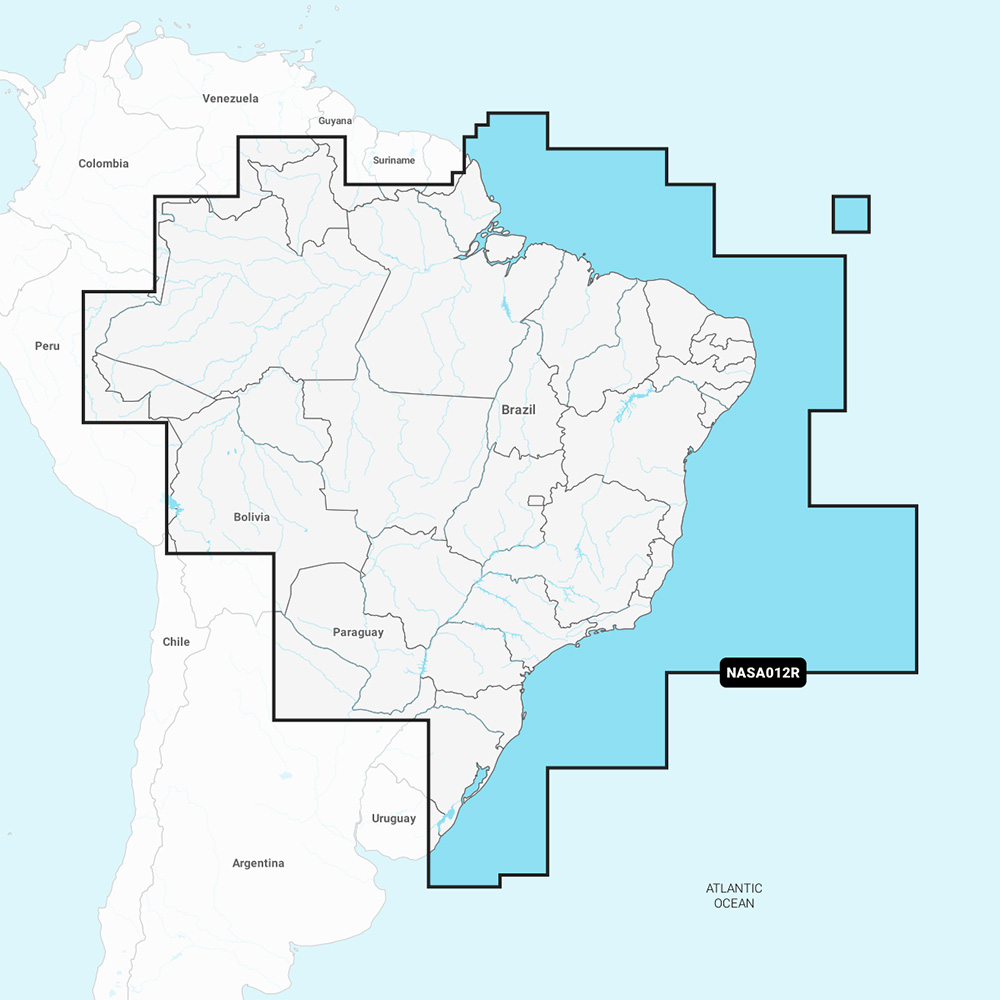
Chart Code: NASA012R

Coverage Area:

  • Detailed coverage of the coast of Brazil. Also including the Amazon River from Benjamin Constant to the Atlantic Ocean.

Features:

  • Coastal Content – Offers detail-rich integrated mapping of coastal waters, lakes, rivers, and more
  • Inland Content – 44,000+ lakes
  • Detailed Nautical Charts – Comprehensive charts are derived from multiple officials, government, and private sources, displayed in a familiar look and feel
  • SonarChart HD Bathymetry – Innovative 1′ (0.5 m) bathymetry charts are created by using Navionics proprietary systems that augment existing content with sonar data contributed by the boating community
  • Daily Updates – Up to 5,000 daily updates to the charts give the most accurate, most current Navionics data available
  • Dock-to-dock Route Guidance2 – Start the trip with a suggested path
  • Plotter Sync1 – Allows compatible chartplotter owners to transfer routes and markers, update chart layers, and more
  • Community Edits – Get useful local knowledge from edits made by users of the Navionics Boating app on a compatible smart device
  • Advanced Map Options1 – Customize the view to focus on the details that matter most
  • SonarChartTM Live Mapping3 – Watch new 1′ personal HD bathymetry maps develop in real-time as the boat moves along the water (it appears as an additional layer over the map, while it also gets stored on the device for future use)

Compatibility:

  • Check the compatibility of Navionics+ content and features with the GPS chartplotter

Technical Specifications:

  • Format: SD/MSD Card

In the Box:

  • SD/MSD Card

1Subscription not required for the SonarChart Live mapping feature on some chartplotter models; requires the latest chartplotter firmware release.

2Dock-to-dock Route Guidance is for planning purposes only and does not replace safe navigation operations.

*Sold as an Individual

This product may not be returned to the original point of purchase. Please contact the manufacturer directly with any issues or concerns.

Weight0.17 lbs
Dimensions5.75 × 4.25 × 0.88 in
MFG#010-C1461-30
UPC821245995384
0 reviews
0
0
0
0
0

There are no reviews yet.

Be the first to review “Navionics NASA012R – Brazil – Navionics+”

Your email address will not be published. Required fields are marked *

1 2 3 4 5
1 2 3 4 5
1 2 3 4 5

Description

NASA012R – Brazil – Navionics+

Get the world’s No. 1 choice in marine mapping – with the best, most up-to-date Navionics+ cartography on a compatible chartplotter. 

For offshore or inland waters, this all-in-one solution offers detail-rich integrated mapping of coastal waters, lakes, rivers, and more. Get SonarChart™ 1’ (0.5 meters) HD bathymetry maps and advanced features such as dock-to-dock route guidance technology, live mapping, and Plotter Sync to provide wireless access to daily updates.

The Navionics Chart Installer software also ensures the freshest chart data every time. Navionics dock-to-dock route guidance solutions suggest a path to follow through channels, inlets, marina entrances, and more. Multiple shading options aid in shallow-water navigation and make it easy to highlight a target depth range for the best fishing spots.

Chart Code: NASA012R

Coverage Area:

  • Detailed coverage of the coast of Brazil. Also including the Amazon River from Benjamin Constant to the Atlantic Ocean.

Features:

  • Coastal Content – Offers detail-rich integrated mapping of coastal waters, lakes, rivers, and more
  • Inland Content – 44,000+ lakes
  • Detailed Nautical Charts – Comprehensive charts are derived from multiple officials, government, and private sources, displayed in a familiar look and feel
  • SonarChart HD Bathymetry – Innovative 1′ (0.5 m) bathymetry charts are created by using Navionics proprietary systems that augment existing content with sonar data contributed by the boating community
  • Daily Updates – Up to 5,000 daily updates to the charts give the most accurate, most current Navionics data available
  • Dock-to-dock Route Guidance2 – Start the trip with a suggested path
  • Plotter Sync1 – Allows compatible chartplotter owners to transfer routes and markers, update chart layers, and more
  • Community Edits – Get useful local knowledge from edits made by users of the Navionics Boating app on a compatible smart device
  • Advanced Map Options1 – Customize the view to focus on the details that matter most
  • SonarChartTM Live Mapping3 – Watch new 1′ personal HD bathymetry maps develop in real-time as the boat moves along the water (it appears as an additional layer over the map, while it also gets stored on the device for future use)

Compatibility:

  • Check the compatibility of Navionics+ content and features with the GPS chartplotter

Technical Specifications:

  • Format: SD/MSD Card

In the Box:

  • SD/MSD Card

1Subscription not required for the SonarChart Live mapping feature on some chartplotter models; requires the latest chartplotter firmware release.

2Dock-to-dock Route Guidance is for planning purposes only and does not replace safe navigation operations.

*Sold as an Individual

This product may not be returned to the original point of purchase. Please contact the manufacturer directly with any issues or concerns.
Specification

Overview

Weight0.17 lbs
Dimensions5.75 × 4.25 × 0.88 in
MFG#010-C1461-30
UPC821245995384

Customer Reviews

0 reviews
0
0
0
0
0

There are no reviews yet.

Be the first to review “Navionics NASA012R – Brazil – Navionics+”

Your email address will not be published. Required fields are marked *

1 2 3 4 5
1 2 3 4 5
1 2 3 4 5